


Miranda del castanar rutas rodales

taguette
User
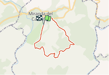

Length
6.9 km

Max alt
723 m

Uphill gradient
101 m
Km-Effort
8.3 km

Min alt
645 m

Downhill gradient
105 m
Boucle
Yes
Creation date :
2023-02-18 12:15:17.077
Updated on :
2023-02-18 14:08:18.86
1h35
Difficulty : Very easy

FREE GPS app for hiking
 SityTrail
IGN / Geographical institutes
SityTrail Plus
The world is yours!
About
Trail Walking of 6.9 km to be discovered at Castile and León, Unknown, Miranda del Castañar. This trail is proposed by taguette.
Positioning
Country:
Spain
Region :
Castile and León
Department/Province :
Unknown
Municipality :
Miranda del Castañar
Location:
Unknown
Start:(Dec)
Start:(UTM)
245971 ; 4485410 (30T) N.
Comments